New Update: Severe Weather Increasingly Likely
- Remington Diedrich
- May 16, 2025
- 4 min read

Good Afternoon Temple! We are currently situated in the cross hairs of a much more substantial outbreak of severe weather in parts of the Tennessee Valley. A rare Level 4/5 risk has been placed for much of that area. Fortunately, we are situated in a Level 1/5 risk for both tonight and tomorrow afternoon. While this may not seem like so much right now, I have speculations that not only this risk may rise, but we have more risks on the horizon.
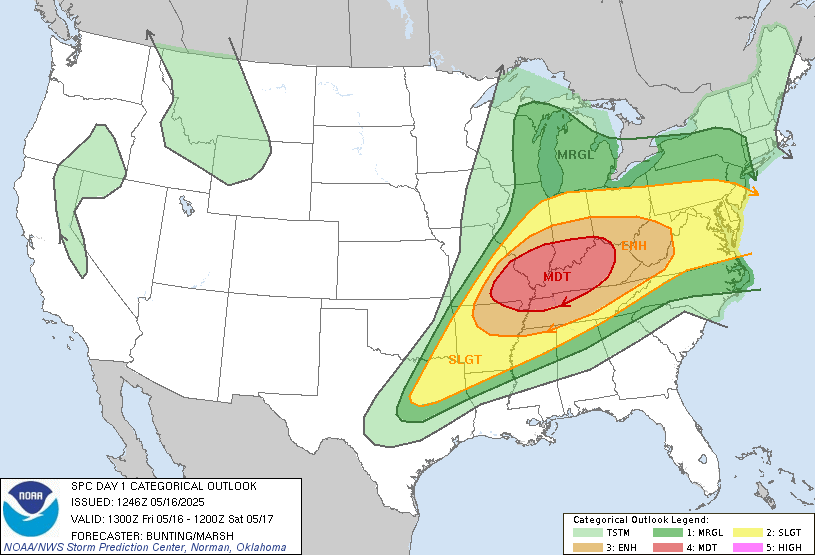

Here is our outlook for Today (left) and Tomorrow (right). You can see that today, most severe weather will remain to our North, but tomorrow may be a different story. We are outlined in a Level 1/5 risk for tomorrow with a threat for Strong Winds in storms.
In this update, we are going to cover some new changes to the forecast including: timing, possible impacts, and more. Find out the latest in our new blog.
Timing Update...
The timing since my last blog has changed quite a bit, and may be a little more beneficial for some plans. Current thinking has changed with new timing sometime around 3 AM - 7 AM for our area. We could see another round of storms in the afternoon, however we will get to that later.

This is using the latest HRRR model, radar at 5 AM. Keep in mind the radar won't exactly look like this at this very time, but can give us a general picture of what to expect. You can see a broken line of showers and storms rolling through the area. This would be a time that some may be waking up, but many will still be asleep. If you have early morning travel commutes, pay attention to a local news source or TempleWXBlog to get the latest on how your travel plans may be affected.
As time has went on, I think there has become increasing confidence in the line holding together enough to bring some gusty winds through the area. While this confidence has increased, there are absolutely still some uncertainties. Let's dive in to the latest models and dissect what impacts should be expected, shall we?
Impacts...
Let's bring up a factor I love to look at when forecasting severe weather, the STP (Significant Tornado Parameter).

This is our STP values just before the line reaches us using the latest HRRR model. Values may not look to high, but favorable severe weather conditions are found in values closer to 1 and 2. You can see we have values up to 2.5 as the line approaches, giving me some additional confidence in severe weather. How is that value calculated? STP is calculated by combining factors such as Atmospheric Instability, Winds in the upper Atmosphere, CAP (the factor that prevents storms from rising), and a few others.
With this type os setup, I am not too concerned with Hail. Hail typically falls in more unstable environments and setups in which the air is cooler than above ground. We don't have either of these factors to a significant degree, thus reducing the expectation of hail with this morning round of storms. Winds are much more frequently associated with these types of storms. These storms are frequently referred to as "Squall Lines" or "Mesoscale Convective Systems (MCSs). I will refer to them as Squall Lines for ease of understanding.
Squall Lines get their name from "Squalls" of wind and rain. These can be associated with passages of cold fronts and tropical cyclones generally speaking. This will be caused by a passage of a cold front. These storms are oriented in lines and can be North to South or West to East generally. In our case, this storm with be West to East for the most part. What really makes the wind in these setups is what's called "Unidirectional Shear".
Unidirectional Shear is winds in the upper atmosphere that are fast but go one direction. These winds are better to translate to the surface, but decrease risks for tornadoes. We will have that in our case, thus, I believe we will face a more substantial damaging wind threat.
Tornadoes as I mentioned are a little more difficult to come by in Unidirectional Shear setups, but with enough of it, anything is possible. Spin-Up tornadoes are absolutely possible, in fact, the 2018 Bremen, GA EF0 occured in a Squall line such as this. While that setup is much more different compared to ours, it is still possible. Keep your guard up tonight, and have a way to receive warnings!
Afternoon Round Impacts...
It is possible we see 2 rounds of storms on Saturday. The morning one is growing more clear and certain, however there is significant uncertainty in a second round in the Afternoon. Models have really been all over the place with this risk, thus I won't show them until we can get a better picture.
The potential is there for a second round of storms, what impacts will depend on the type of storm they are. If they are more discrete and by themselves, All-Hazards, including Wind, Hail, and Tornadoes will be possible. If they are more similar in nature to the morning storms, strong winds and isolated tornadoes would be the greatest concern. This is something that remains unknown, thus I won't make too many comments on it. I would lean towards the risk of something similar to the morning, with a low end threat for some isolated severe weather. Keep your eyes on the sky, and TempleWXBlog for future information regarding this threat!
Recap...
All in all, 2 rounds of storms are possible tonight and tomorrow afternoon. Strong winds will likely be the main concern, but keep your eyes peeled for the threat of localized tornado potential in a few storms. There is still no need for panic or action as of this moment, as we are still only outlined in a Level 1/5 risk, but don't let your guard down. Stay tuned to TempleWXBlog for new updates regarding this situation.
Author: Remington Diedrich


Comments