Top 10 Warmest Winter on Record? Find out in our Winter Weather Forecast!
- Remington Diedrich
- Oct 22, 2024
- 4 min read

Some winters you remember, maybe for their chill or their snow. This one may go down as the opposite. The winter of 2016-2017 is not a season that stands out in most people's memories due to it having the highest winter temperatures ever recorded in Atlanta. Severe weather plagued Georgia that winter, and snow really never came in the forecast. This year may rival that said winter as one of the warmest on record for Georgia. Your winter weather forecast contains 4 big predictions: Temperature, Precipitation, Snowfall, and Severe Weather. What will this year's winter be remembered for? Find out in this blog!
Temperature...

(CPC)
This is the latest Temperature Outlook for the Climate Prediction Center. Not a drop of below average in the lower 48. It looks clear that around here, we will be seeing Above Average temperatures, potentially well above. Howeverm there are some much deeper patterns evolving than just "Above Average Temperatures"
Let's take a closer look!
One of the patterns we, as meteorologists, look at is ENSO. This is characterized by either El Niño or La Niña. El Niño is when warm water is present in the central Pacific Ocean, while La Niña is the opposite. You may be asking, "How does that effect our weather?" Well, they change the tracks that storms follow when they hit the US. El Niño provides a southerly track and a stronger jet stream, while La Niña, again, is the opposite. What we are seeing this year is a La Niña.

This graphic does a great job of showing what a La Niña is and how it promotes a weaker, more northerly jet stream. North of the jet stream is where you find your most likely snow and cold weather, while to the south it is hotter and drier. We end up well south of the jet stream and storm track, leading to hotter, drier, and less snowy conditions.
Precipitation...
As just mentioned, our ENSO pattern is projecting a potentially drier winter. This is reflected on our Climate Prediction Center outlook.

(CPC)
You can almost see where they think the jet stream will be based on this image alone. Remember, north of the Jet Stream is Wet, south is dry. Since we are located to the south, we are predicted to have atleast slightly below average precipitation. The easiest way we can tell this is yet again, through ENSO.
How does ENSO help us?
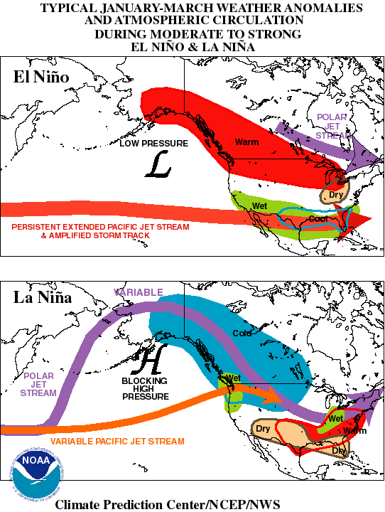
This is La Niña vs. El Niño storm tracks. As shown, the La Niña track is much more north, promoting less precipitation. This also promotes a warmer climate across the region. If this storm track is generally true, we would likely experience extended periods of dry weather, with periodic rains. I don't see a "heavy rain" pattern with this setup, so expect periodic rains and storms.
Snowfall...
Overall, the look we have this year just is not very conducive to snow. Lack of precipitation and a more northerly storm track look to prevent a big snow. Not to say we won't get cold blasts and some snow. In fact, the big snows we saw in the 2017-2018 year fell under La Niña conditions. In fact, there are some indicators pointing towards some snow this year.

This forecast is generally what I would consider accurate. An average to slightly below average chance for snow this year. That might hurt for some of you wanting to go to the mountains or skiing this year, but all hope is not lost.
Bonus: Farmers Almanac Forecast

This is our Almanac's winter prediction. As you can see, a wetter and snowier approach is expected. In fact, they are calling for a "big winter storm" to affect some parts of the area by mid-winter. If that plays out, we could see above-average snowfall totals for the year! You all know I will keep my eyes on it and will keep you posted if new information is released.
Severe Weather...
Let me start off with this, Severe Weather season never ends in the south. At all times of the year, we need to be alert for severe weather. And with the look we have this winter, I am especially on guard for severe weather.
With a hotter and drier look, we will have more time to create unstable warm environments. This could prove to be dangerous, as similar winters to this have seen big tornado outbreaks. AccuWeather meteorologist Paul Pastelok had this to say about our upcoming winter.
"With mild air masses coming out of the west during the month of January, we could see the potential for severe weather farther north into places like Missouri, Arkansas, and Tennessee. As the jet stream dips farther south in February, we could start to see more severe weather in the Gulf coast states with warmer air and warmer waters from the Gulf of Mexico."
As this ever-changing climate continues to warm, we will continue to see more and more severe weather in winter months. Always check the latest blog posts for the best information!
Outlook...
Overall, a drier, warmer winter can be expected. Exact dates and locations of any big storms won't get nailed down until then but do expect some periodic storms to roll through the area, just not quite what we see on a normal basis. Any big snow chances would likely come around the January/February timeframe, but that's a big if. Finally, severe weather will be a big factor through all the winter months as storm systems bring moist air up from the Gulf.
What if there is a major update, the next big storm, or a cold plunge incoming? How will you know well in advance? Subscribe to our newsletter now! You get emails every time a blog post is released and get put in the know. Subscribe below, or become a member today!
Author: Remington Diedrich


Comments